A dam is any artificial barrier, the type heap or other type, which can hold water or store water either natural or artificial, including foundation, hill / cliff pedestal, as well as complementary buildings and equipment. In this sense, including also the dam excavation waste but does not include dam and embankment. In terms of the construction of the dam consists of a dam embankment and concrete dams. Dam embankment dam embankment consists of uniform (homogenous), dam pile of stones with waterproof coating inside the dam body (claycore rockfill dam, dam zone) and a heap of rubble dam with water-resistant coating on the face (concrete face rockfill dam).
Moderate concrete dam consists of a concrete dam based on its own weight (gravity concrete), concrete dam with a buffer (buttress dam), arch-shaped concrete dam (concrete arch dam), and concrete dam over a curved shape (multiple arch dam) (source KNI -BB). Based on the size Jatiluhur Dam belongs to the large dam.
Water collected as a result of the construction of the dam is usually used for irrigation, water supply raw water for drinking, industrial and urban areas, fisheries and power generation. Another benefit is the dam for flood control and tourism. Besides to hold water, the dam is also built to accommodate other materials, such as effluent / waste mining and cold lava. Dam to withstand cold lava also called sabo dams (sabo dam).
After the Second World War, is associated with a sharp increase in population, the need for food and electricity, both for households and industry, increased rapidly. The Indonesian government decided to carry out the construction of large dams in the northern province of West Java, to meet the food supply and electricity.
During the implementation period, the construction project is called "Jatiluhur Multipurpose Project" and is named after the settlement becomes Juanda Dam and Power Plant, as a memento of the role of the Prime Minister last Indonesia Ir. H. Juanda in the realization Jatiluhur dam construction.
Basically Jatiluhur Dam construction project is made for the purposes of irrigation and electricity, but it has other purposes, the raw water supply, flood control, flushing town, inland fisheries, and tourism.
Location Jatiluhur Dam.
Jatiluhur dam located approximately 100 km to the East of Jakarta, which can be achieved through Jakarta Cikampek toll roads and toll roads Cipularang (the Cikampek - Jatiluhur), and 60 km to the North West London, which can be reached via highways Cipularang (segment Bandung - Jatiluhur ). City of Purwakarta about 7 miles west direction. Based on geographic coordinates, body position Jatiluhur Dam is at 6o31 'south latitude and 107o23' east longitude. Red box on the left image shows the position Jatiluhur Dam on the map.Jatiluhur Dam is the biggest dam in Indonesia, stemming the flow of the Citarum River in District Jatiluhur - Purwakarta - West Java Province, forming a reservoir with a puddle of ± 83 km2 and around the reservoir 150 miles on a normal water surface elevation +107 m above sea level (asl ). Figure 3-5 is a plan Jatiluhur area before and after flooding. Dam catchment area is 4,500 km2 Jatiluhur. While the immediate catchment area into the reservoir after a dam was built on the upper reaches Saguling and Cirata be living 380 km2, which is 8% of the total catchment area. Catchment area (upper Citarum) covers an area of Bandung District, West Bandung Regency, Bandung, Cimahi, Cianjur and Purwakarta. In the first bin is designed to have a capacity of 3 billion m3, but currently living 2.44 billion m3 (bathymetry measurements results in 2000) due to sedimentation.
However, after the dam was built and Cirata Saguling on it, the sedimentation rate decreases. Jatiluhur Dam is a multipurpose dam, to function as a power plant with installed capacity of 187.5 MW, control floods in Karawang and Bekasi, 242,000 ha for irrigation, water supply for domestic, industrial and city flushing, the water supply for brackish water aquaculture along the northern coast of West Java area of 20,000 ha, and tourism. This dam was built in 1957 was marked by the laying of the foundation stone by the first President Ir. Sukarno. Dated 19 September 1965 is the last visit Ir. Sukarno to Jatiluhur Dam, which is eleven days before the outbreak of the events of the G 30 S PKI. On the occasion of Cabinet Meeting was held Dwikora.
Both the inauguration by President General Soeharto on August 26, 1967. Total costs incurred for the construction of Dam Ir. H. Juanda to finish was U.S. $ 230 million. This fee covers the cost in dollars and dollars.
To commemorate the services of Ir. H. Juanda (full name Ir. Djoeanda Kartawidjaja HR) in the fight for development financing Jatiluhur dam, the dam was officially named Dam Ir. H. Juanda. He was the last Prime Minister of the Republic of Indonesia and led cabinet work (1957-1959). Ir H Juanda Kartawidjaja, Technische Hogeschool graduates (College of Engineering) - now the Institute of Technology Bandung (ITB), which had previously been minister of whom the Minister of Transport, Water, Wealth, Finance and Defence. He together with Ir. Sedijatmo to actively fight for the realization of projects in Jatiluhur Indonesian Government and international forums. On his last visit Ir. Sukarno delivered an order to complete construction Jatiluhur dam at the end of April 1966, but was not implemented because the G 30 S PKI rebellion.
Citarum River.
As the longest and largest river in West Java, flowing along approximately 270 km from springs in Mount Wayang in Bandung regency, to its mouth in the Java Sea through the Bandung District, West Bandung, Cianjur, Purwakarta, Karawang regency administration divides and from Kedung Gede Bekasi and downstream ends of the estuary as the kingpin of the Citarum River estuary into the Java Sea. Citarum River has a volume average annual flow of 5.5 billion m3, 6,600 km2 basin area. It has high annual rainfall average of 2353 mm, with 80% of the rain falling in the period from November - MayCitarum river with several other rivers in the northern part of West Java, namely: Ciherang, cilamaya, Cijengkol, Ciasem, Cigadung, Cipunegara, and Cilalanang forming an integrated hydrological region, with an area of 1,100,000 ha hydrological unit. The image below is Pangsiraman Springs, which is one of the seven springs Citarum River is located in Mount Wayang - Ciwidey. Name six other springs Citarum River is Cikahuripan, Cikawedukan, Cisanti, Cikaloberes, Cisadane / Cihaliwung and Cikadugalan / Cipaedah. The seven springs are located in an area that has a height Situ Cisanti +2180 m asl.
In 1984 and 1987 operating 2 pieces of large dams in the upstream dam Ir. H. Juanda, namely Saguling Dams and Dam Cirata. With the construction of the two dams, the overall bin capacity becomes equal to the annual flow of the Citarum River.
The idea Jatiluhur dam.
The idea of building a dam on the river Citarum dudah began in the 19th century by irrigation experts at that time to have done the initial survey include topographical and hydrological surveys. Even the Citarum river discharge measurements for purposes of dams and irrigation has been started in 1888.The idea of development is then developed and refined by prof. Dr.. Ir. W.J. van Blommestein, an irrigation expert Dutch in 1930. The idea is for the first time presented at the annual meeting of the Association of Engineers of the Netherlands (Koninklijk Instituut van Ingenieurs or Kivi) dated December 18, 1948 in Jakarta, with the title "Een Federaal Welvaartsplan voor het Westelijk Gedeelte van Java". At that time, Professor. Ir. W.J. van Blommestein, head of the Dutch Water Planning Bureau, has been conducting a survey in greater detail to make a plan to build three large reservoirs along the Citarum river basin; Saguling (previously called Reservoir Tarum by prof. Ir. WJ van Blommestein), Cirata and Jatiluhur.
Furthermore, Prof.. W.J. van Blommestein up to an idea where in addition to the potential of the three reservoirs in the Citarum River, there is also the potential for the development of inter Watershed (DAS) for rivers in Java, known in his writings titled "A Development Project for the Island of Java and Madura "in August 1979. The idea that time is Jatiluhur only developed for irrigation and the construction of canals to transport water from Anyer to pass Solo Surabaya.
Prof. Ir. Wilem Johan van Blommestein was born in the city of Solo Kertasura dated May 15, 1905 and died on August 11, 1985. Lecture at the Bandung Institute of Technology in 1924 and graduated with a degree engineer in 1928. In this he is also directly assigned to the section area of Falkirk. A year later he moved to Purworedjo, working as an engineer in the field of irrigation. 1931 to 1934 he served in Yogyakarta.
Other works are one of the largest dams built in Suriname, which later was named Dam Blommestein. This dam has a vast pool of 1,560 km2, with a height of 54 m. Overall dam crest length of 12,000 m. Catchment area of 12,000 km2. Dam was built in 1960 and was completed in 1964.
Prof. idea. Dr.. Ir. W.J. van Blommestein then reviewed by Ir. Van Scravendijk 1955 with a paper entitled "Integrated Water Resources Development in the Citarum River Basin" (240,000 ha of rice fields). The idea is then fitted by Ir. Abdullah Angudi 1960 through a memorandum of management thus becomes Multipurpose Project Development Master Plan Jatiluhur.
The idea to build a dam in Citarum river basin pioneered back in the 1950's era. Ir. Agus Prawiranata as the Surgeon Irrigation then start thinking about the development of the irrigation network in anticipation of the adequacy of domestic rice. At that time, Indonesia has become the world's biggest rice importer. However, to build a large-scale dams, when it was still a laughing matter, because the GOI has not got the money.
Then the idea was discussed with Ir. Sedyatmo, who was serving as head of the Board of Directors of the State Electricity Generating Board Construction, Directorate General of Man Power, Ministry of Public Works and Electric Power. Incidentally, PLN had time budget and it was working to find a replacement power source that still use oil, because it is expensive. Then, Ir. Sediyatmo commissioned Ir. P.C. Harjosudirdjo (now; Prof. DR. Ir. PK Haryasudirja) when the Board of Directors as Assistant Head of PLN Construction, to design the reservoir dam.
Before the construction of dams Jatiluhur, the northern part of West Java Province has built several water resources infrastructure, such as dams Walahar, Pundong, Salamdarma, Barugbug and so on. But each water resources infrastructure is not yet integrated and function as weirs, can not hold water in the rainy season so that the rainy season is always flooding and drought in the dry season. The intensity of cropping (crop intensity) only 1, which is 1 times the planting year. Then the agricultural area largely controlled by the landlords, and most farmers are tenants who do not own land.
It is important that the time is also a consideration, according to Prof. DR. Ir. P.K. Haryasudirja, then an Assistant Jatiluhur Affairs who handles the planning and execution of construction, is the consideration of water supply to Jakarta. When the port of Tanjung Priok never visited foreign ships, because not enough water for boat supplies. So the export-import activities of Tanjung Priok faltered. Haryasudirja which makes specification Jatiluhur dam, claiming to imitate the style world's largest dam, the Aswan dam in Egypt. Using consultants from France who have experience in building a big dam.
Jatiluhur dam period.
Jatiluhur Project construction period is also unique, because it had experienced nine times the turn of the cabinet from the Cabinet Works Cabinet Ampera 1957 until 1967.Ministers of Public Works and Energy in Jatiluhur dam construction period is Ir. Prince Mohamad Noor, Ir. Sardjono Dipokusumo, Maj. D. Suprayogi, and Dr.. Ir. Sutami. 1965 PUT in compartment Development Minister Maj. D. Suprayogi charge of 6 ministries namely: Ministry of Electricity and Power Ir. Setiadi Reksoprodjo, Minister of Irrigation Basics Ir. Peter Canisius Hardjosudirdjo, Minister Maj. tycoon Binamarga Wirjodiprodjo, Ciptakarya and Construction Minister David Cheng, Secretary of Sumatra trans Ir. Bratanata and State Minister to the Coordinating Minister for Public Works and Energy Ir. Sutami.
It should be noted that this is the period of development of the French was never completed Jatiluhur dam construction. On October 15, 1965, ie 15 days after the outbreak of the G 30 S PKI, foreign experts return to his country. At that time most of the main spillway tower construction has not been completed and the top of the saddle dam Pasirgombong West and East have not made. The completion of the remaining work was carried out independently by experts from Indonesia using equipment left behind.
However, during the inauguration of President Suharto Jatiluhur Dam, the work is still not completed one hundred percent. Spillway helper (auxiliary) which is in the left pedestal Ubrug Saddle Dam is not in accordance with the original plan, the radial gate at the second window. This is due to the cost of completion is no longer available.
In order Jatiluhur dam can operate as planned, at the fourth window is made of concrete spillway Ubrug maid soft curved peak elevation +111.6 m, the maximum flood elevation. Ubrug maid spillway operated by blowing soft concrete arch. However, during operation Jatiluhur dam, spillway maid has not been operated.
Here are the experts / engineers early period of development Jatiluhur Dam:
Ir. Patti (not to completion)
Ir. Umar Masduki
Ir. Ahmad Musa
Ir. Donardi Senosarto
Ir. Sutopo
Ir. Sudarjo
Ir. Asban Basiran (currently still assist the Board of Directors of PJT II as Senior Personnel in the field of dam)
Ir. Samsiar
6. Puddle Regional Demographics
Inundation caused by dam construction Jatiluhur 14 drowned village with a population of 5,002 people. Population is then partially transferred to the area around the dam and others moved to the Khanewal district. Most of the population at that time working as a farmer.
Electricity Production.
The first electricity production started in 1965 and routed to London through the air channel high voltage 150 kV PLN. Distribution of the new Jakarta conducted in 1966. VI Hydroelectric new unit installed by PT. PLN Pikitdro Jabar between the years 1979 - 1981 with a capacity of 32 MW.Jatiluhur Dam Design.
The process of planning the construction of dams in the Citarum River starts from the determination of the location. Based on the original idea of Prof.. Dr.. Ir. W.J. van Blommestein entitled "Integrated Water Resources Development in the Western Part of Java Island", planned to be built three dams on Jatiluhur. The first investigations carried out by the State Electricity Company (PLN), who was still under the Department of Public Works and Energy, by hiring experts from France.In accordance with the concept of the construction of dams, which starts from hick to downstream, starting with the initial plan development in the area Padalarang measurements, ie Saguling current dam location. Measurements can not be forwarded because the execution time of the crash forces many DI / TII, killing several officers died measurement. Measurement is then moved to the next location, ie the location of the current around the dam Cirata. Just like with Padalarang area, at this location was a disruption of DI / TII, so finally measurements performed in the vicinity of the Jatiluhur. Consider the security issues and the urgent need for irrigation, it was decided Jatiluhur dam construction.
Having determined the location of the body plan of the dam, started the design work on the way to experience some changes. Design process and the changes that occur both during design and during construction are as follows:
Preliminary Design (Preliminary Design).
Jatiluhur dam was first designed by Neyrpic Laboratory (since 1955 Neyrpic Laboratory turns into Sogreah), circa 1953. Sogreah (first Neyrpic Laboratory) is a French company engaged in the planning consultation which also has a manufacturing plant electric generating units (specifically the manufacture of turbines and waterways).Unlike the current design, arc-shaped dam plan with radius 360 m to the hick with a side spillway is located on the left of the dam. The length of the dam is shorter because it uses a hick peninsula located in the dam today. Dodger tunnel located on the left dam, amounting to two pieces with a diameter of 10.5 m. One dodger planned tunnel will be used as a power plant intakes. Has 4 electric generating units located in the downstream of the dam with dam-making on the left, (the location on the body of the dam is now on the left) take advantage of the diversion tunnel partially right.
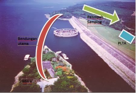
Illustration Plans Dam Body Location Based Preliminary Design
Technical data is based on preliminary design Jatiluhur Dam are as follows:Type of Dam: Stone Heaps with sloping clay core.
Peak width: 6 m.
Dam crest elevation: +111.00 m.
Slope: U / S 1: 1.4, (D / S) is also 1: 1.4.
Overflow: side-channel spillway is open, use 4 pieces of door width spending each 8 m, with a hick spillway elevation +88.00 m and +21.00 m downstream. Spillway width of 20 m.
Hydropower: 4 units, located in the downstream of the dam. Locations around the body of the dam is now. Intake diversion tunnel utilizing the right.
Cofferdam crest elevation hick: +41 m.
Channels dodger: two numbered, each with a diameter of 10.50 m.
This plan was not passed because based on the results of geological investigations indicate there is a hill right pedestal syncline with a coating that is skewed towards downstream. While geological conditions unfavorable location spillway.
Both designs.
The next dam design done by A. Coine & J. Beller Consulting Engineers Paris. The design is made still shaped arc, but the direction is opposite to the previous design, the arc-shaped downstream. Taking into account the existing geological conditions, the hill pedestal shifted to the downstream dam, approximately 100 m. The hillside location pedestal in the second design is exactly the same as the location of the current dam hill pedestal.Spillway design changed from the previous use of spillway side, on this second design using morning glory spillway structure (see previous explanation about the morning glory spillway). While hydropower united in building the tower morning glory. Location of hydropower dams in hick unusual, usually located at the downstream of the dam. Consideration of hydropower united with spillway tower building is based on efficiency, meaning that it need not be a separate building for building hydropower (downstream height difference not significant) and the intake to the hydro is not too long so as to reduce loses.
Technical data is based on preliminary design Jatiluhur Dam are as follows:
Type of Dam: Stone Heaps with sloping clay core.
Peak width: 10 m.
Dam crest elevation: +114.50 m.
Slope: U / S 1: 1.4, (D / S) is also 1: 1.4.
The main spillway tower: Type Morning Glory, Ogee, 14 windows, without doors, summit elevation +107 m, 151.5 m long summit, with 14 pieces of the window. Capacity of 3,000 m3 / s at maximum elevation. Outer diameter of 90 m tower. 110 m high tower.
Cofferdam crest elevation hick: +65 m.
Channels evader: the fruit, with a diameter of 10.50 m, is on the right tower, contrary to previous designs.
Final Design.
Final design of the dam is mostly the same with the second design. What distinguishes it is the footprint and the slope of the clay core of the dam. At the end of this form of design is shifted upstream as the dam, causing the distance to the dam body building towers become increasingly close. Other changes are the clay core which has a steeper slope than ever before.This change was made during the construction period. At the time of construction of the tower and Tailrace / access gallery was completed in 1962, found that a shift occurs in the joint 1 and 2 and the access gallery Tailrace downstream. To obtain further information at the time it was drilled and the foundation found that slippery layer of clay seam between sandy claystone and claystone sloping downstream.

Based on the analysis of concerns that the joint shift 1 and 2 as a result of a shift in the base layer. It was decided at that time to do the anchorage of the foundation layer.
Installation is done by using an iron anchor concrete screw diameter of 32 mm.
After the installation of the anchor, there are concerns if the dam body in accordance with the design, dam body will experience a shift in the downstream direction. Considering the above, the design adapted to existing conditions, so that the design of the dam body to be like the picture below:

Note:
1 Diversion Structure
2 Downstream cofferdam
3 Upstream cofferdam
4 Main Dam
Technical Data Jatiluhur Dam based on the final design.
Remedial Work.
In 1996 Remedial Work carried out with the aim to improve the stability of the dam body. One of the activities of the Remedial Work-right ramp slope is the main dam and downstream parts hick. Thank you for reading this article.
Written and posted by Bambang Sunarno. sunarnobambang86@gmail.com
author:
http://schema.org/Personal.
https://plus.google.com/105319704331231770941.
name: Bambang Sunarno.
http://primadonablog.blogspot.com/2014/02/history-jatiluhur-dam.html
DatePublished: February 18, 2014 at 11:47
 7MHPNPADAEFW
Tag ; Jatiluhur Dam History?, jatiluhur dam
No comments:
Post a Comment